


Surceneux Gérardmer

surceneux
User
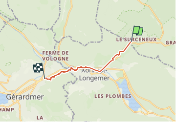

Length
6.7 km

Max alt
837 m

Uphill gradient
85 m
Km-Effort
8.4 km

Min alt
668 m

Downhill gradient
251 m
Boucle
No
Creation date :
2022-07-30 13:24:20.731
Updated on :
2022-07-30 14:48:08.456
1h20
Difficulty : Very easy

FREE GPS app for hiking
 SityTrail
IGN / Geographical institutes
SityTrail Plus
The world is yours!
About
Trail Walking of 6.7 km to be discovered at Grand Est, Vosges, Ban-sur-Meurthe-Clefcy. This trail is proposed by surceneux.
Description
Surceneux Gerardmer par sentier Gourier
Positioning
Country:
France
Region :
Grand Est
Department/Province :
Vosges
Municipality :
Ban-sur-Meurthe-Clefcy
Location:
Unknown
Start:(Dec)
Start:(UTM)
347576 ; 5329032 (32U) N.
Comments