


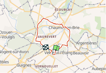
verneuil l'étang et chaumont en brie

Grouchat
User

Length
10.7 km

Max alt
114 m

Uphill gradient
119 m
Km-Effort
12.3 km

Min alt
69 m

Downhill gradient
120 m
Boucle
No
Creation date :
2022-07-30 08:21:54.522
Updated on :
2022-07-30 16:33:53.444
3h19
Difficulty : Medium

FREE GPS app for hiking
 SityTrail
IGN / Geographical institutes
SityTrail Plus
The world is yours!
About
Trail Walking of 10.7 km to be discovered at Ile-de-France, Seine-et-Marne, Verneuil-l'Étang. This trail is proposed by Grouchat.
Positioning
Country:
France
Region :
Ile-de-France
Department/Province :
Seine-et-Marne
Municipality :
Verneuil-l'Étang
Location:
Unknown
Start:(Dec)
Start:(UTM)
487378 ; 5387892 (31U) N.
Comments