


Génillé - Parcours 35 - La Touraine à pied D037

sberthier
User
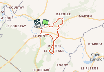

Length
10.6 km

Max alt
128 m

Uphill gradient
150 m
Km-Effort
12.6 km

Min alt
78 m

Downhill gradient
151 m
Boucle
Yes
Creation date :
2022-07-31 07:52:07.275
Updated on :
2022-07-31 10:28:38.782
2h15
Difficulty : Very easy

FREE GPS app for hiking
 SityTrail
IGN / Geographical institutes
SityTrail Plus
The world is yours!
About
Trail Walking of 10.6 km to be discovered at Centre-Loire Valley, Indre-et-Loire, Genillé. This trail is proposed by sberthier.
Description
Parcours issu du Topo-Guide La Touraine à pied (épuisé). Plus de balisage.
Positioning
Country:
France
Region :
Centre-Loire Valley
Department/Province :
Indre-et-Loire
Municipality :
Genillé
Location:
Unknown
Start:(Dec)
Start:(UTM)
355861 ; 5227450 (31T) N.
Comments