


croix de bauzon aigle royal

07es18
User
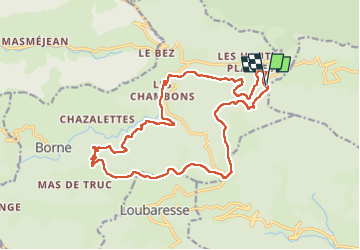

Length
20 km

Max alt
1463 m

Uphill gradient
565 m
Km-Effort
28 km

Min alt
1153 m

Downhill gradient
565 m
Boucle
Yes
Creation date :
2022-07-31 06:55:42.952
Updated on :
2022-08-08 06:25:56.209
5h16
Difficulty : Medium

FREE GPS app for hiking
 SityTrail
IGN / Geographical institutes
SityTrail Plus
The world is yours!
About
Trail Walking of 20 km to be discovered at Auvergne-Rhône-Alpes, Ardèche, Borne. This trail is proposed by 07es18.
Positioning
Country:
France
Region :
Auvergne-Rhône-Alpes
Department/Province :
Ardèche
Municipality :
Borne
Location:
Unknown
Start:(Dec)
Start:(UTM)
586362 ; 4942476 (31T) N.
Comments