


les balcons du Champsaur

chrifor
User
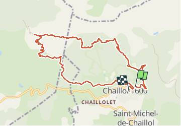

Length
12.2 km

Max alt
1987 m

Uphill gradient
514 m
Km-Effort
19.1 km

Min alt
1573 m

Downhill gradient
549 m
Boucle
No
Creation date :
2022-07-31 08:40:48.655
Updated on :
2022-07-31 15:37:39.37
4h04
Difficulty : Medium

FREE GPS app for hiking
 SityTrail
IGN / Geographical institutes
SityTrail Plus
The world is yours!
About
Trail Walking of 12.2 km to be discovered at Provence-Alpes-Côte d'Azur, Hautes-Alpes, Saint-Michel-de-Chaillol. This trail is proposed by chrifor.
Photos


Positioning
Country:
France
Region :
Provence-Alpes-Côte d'Azur
Department/Province :
Hautes-Alpes
Municipality :
Saint-Michel-de-Chaillol
Location:
Unknown
Start:(Dec)
Start:(UTM)
275489 ; 4952349 (32T) N.
Comments
xx