


Fleurie - Roche Solutre - Julienas

henristraetmans
User
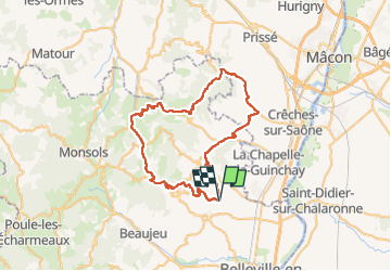

Length
54 km

Max alt
748 m

Uphill gradient
1222 m
Km-Effort
71 km

Min alt
231 m

Downhill gradient
1221 m
Boucle
Yes
Creation date :
2022-07-31 08:36:21.765
Updated on :
2022-08-02 08:01:14.452
3h30
Difficulty : Very difficult

FREE GPS app for hiking
 SityTrail
IGN / Geographical institutes
SityTrail Plus
The world is yours!
About
Trail Road bike of 54 km to be discovered at Auvergne-Rhône-Alpes, Rhône, Fleurie. This trail is proposed by henristraetmans.
Description
Magnifique rando dans les villages du beaujolais et vue depuis la terasse (maison des crus de Chiroubles)
Retour par la Roche de solutre, Saint Veran, Saint Amour, Julienas
Positioning
Country:
France
Region :
Auvergne-Rhône-Alpes
Department/Province :
Rhône
Municipality :
Fleurie
Location:
Unknown
Start:(Dec)
Start:(UTM)
630673 ; 5115115 (31T) N.
Comments