


Footing Plateau Leucate

Fab-Oz
User
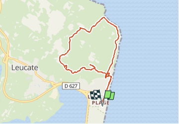

Length
8.8 km

Max alt
60 m

Uphill gradient
140 m
Km-Effort
10.7 km

Min alt
1 m

Downhill gradient
141 m
Boucle
Yes
Creation date :
2022-08-01 06:42:34.13
Updated on :
2022-08-01 07:46:59.6
1h00
Difficulty : Easy

FREE GPS app for hiking
 SityTrail
IGN / Geographical institutes
SityTrail Plus
The world is yours!
About
Trail Running of 8.8 km to be discovered at Occitania, Aude, Leucate. This trail is proposed by Fab-Oz.
Positioning
Country:
France
Region :
Occitania
Department/Province :
Aude
Municipality :
Leucate
Location:
Unknown
Start:(Dec)
Start:(UTM)
504415 ; 4749726 (31T) N.
Comments