


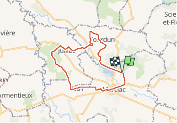
Les coteaux de Marciac-PR1

parastat
User

Length
14.6 km

Max alt
226 m

Uphill gradient
262 m
Km-Effort
18.1 km

Min alt
144 m

Downhill gradient
269 m
Boucle
Yes
Creation date :
2022-08-01 05:29:01.056
Updated on :
2022-08-01 11:53:04.478
3h42
Difficulty : Difficult

FREE GPS app for hiking
 SityTrail
IGN / Geographical institutes
SityTrail Plus
The world is yours!
About
Trail Walking of 14.6 km to be discovered at Occitania, Gers, Marciac. This trail is proposed by parastat.
Description
Départ du camping du lac.
Assez sympa, peu de goudron.
Hélas chien très agressif au lieu dit Castay et un autre au lieu dit Minic; merci les bâtons de rando, juste suffisants pour les éloigner.
Positioning
Country:
France
Region :
Occitania
Department/Province :
Gers
Municipality :
Marciac
Location:
Unknown
Start:(Dec)
Start:(UTM)
271099 ; 4823872 (31T) N.
Comments