


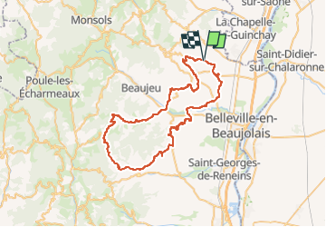
Fleurie - col croix rosier - mont Brouilly

henristraetmans
User

Length
62 km

Max alt
750 m

Uphill gradient
1270 m
Km-Effort
79 km

Min alt
200 m

Downhill gradient
1271 m
Boucle
Yes
Creation date :
2022-08-01 08:39:01.69
Updated on :
2022-08-02 08:00:09.441
3h30
Difficulty : Very difficult

FREE GPS app for hiking
 SityTrail
IGN / Geographical institutes
SityTrail Plus
The world is yours!
About
Trail Road bike of 62 km to be discovered at Auvergne-Rhône-Alpes, Rhône, Fleurie. This trail is proposed by henristraetmans.
Description
Traversée dans les crus de Chirouble, Regnie, Morgon, Brouilly, côte de Brouilly et Fleurie
Ascension du col croix rosier et du mont Brouilly
Magnifique passages et points de vue
Positioning
Country:
France
Region :
Auvergne-Rhône-Alpes
Department/Province :
Rhône
Municipality :
Fleurie
Location:
Unknown
Start:(Dec)
Start:(UTM)
630671 ; 5115118 (31T) N.
Comments