


Laitre AR

JeanPierreNancy
User
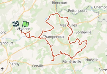

Length
51 km

Max alt
317 m

Uphill gradient
708 m
Km-Effort
60 km

Min alt
194 m

Downhill gradient
693 m
Boucle
No
Creation date :
2022-08-01 09:06:56.258
Updated on :
2022-08-01 16:07:05.081
3h54
Difficulty : Medium

FREE GPS app for hiking
 SityTrail
IGN / Geographical institutes
SityTrail Plus
The world is yours!
About
Trail Mountain bike of 51 km to be discovered at Grand Est, Meurthe-et-Moselle, Laître-sous-Amance. This trail is proposed by JeanPierreNancy.
Positioning
Country:
France
Region :
Grand Est
Department/Province :
Meurthe-et-Moselle
Municipality :
Laître-sous-Amance
Location:
Unknown
Start:(Dec)
Start:(UTM)
299646 ; 5403334 (32U) N.
Comments