


ARBORETUM

gallo
User
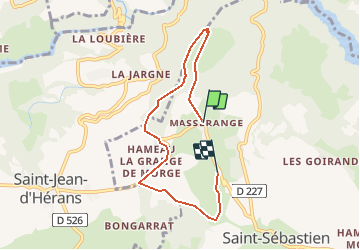

Length
6.1 km

Max alt
949 m

Uphill gradient
162 m
Km-Effort
8.2 km

Min alt
826 m

Downhill gradient
141 m
Boucle
No
Creation date :
2014-12-10 00:00:00.0
Updated on :
2014-12-10 00:00:00.0
1h47
Difficulty : Easy

FREE GPS app for hiking
 SityTrail
IGN / Geographical institutes
SityTrail Plus
The world is yours!
About
Trail Walking of 6.1 km to be discovered at Auvergne-Rhône-Alpes, Isère, Châtel-en-Trièves. This trail is proposed by gallo.
Positioning
Country:
France
Region :
Auvergne-Rhône-Alpes
Department/Province :
Isère
Municipality :
Châtel-en-Trièves
Location:
Saint-Sébastien
Start:(Dec)
Start:(UTM)
720219 ; 4971328 (31T) N.
Comments