


Carlepont

fitz2014
User
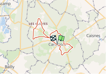

Length
12.1 km

Max alt
87 m

Uphill gradient
117 m
Km-Effort
13.6 km

Min alt
40 m

Downhill gradient
116 m
Boucle
Yes
Creation date :
2022-08-02 10:03:59.743
Updated on :
2022-08-02 10:16:02.222
3h11
Difficulty : Difficult

FREE GPS app for hiking
 SityTrail
IGN / Geographical institutes
SityTrail Plus
The world is yours!
About
Trail Walking of 12.1 km to be discovered at Hauts-de-France, Oise, Carlepont. This trail is proposed by fitz2014.
Positioning
Country:
France
Region :
Hauts-de-France
Department/Province :
Oise
Municipality :
Carlepont
Location:
Unknown
Start:(Dec)
Start:(UTM)
501926 ; 5484470 (31U) N.
Comments