


Prunelles cabardes

Villatet
User
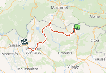

Length
44 km

Max alt
1104 m

Uphill gradient
817 m
Km-Effort
56 km

Min alt
392 m

Downhill gradient
1140 m
Boucle
No
Creation date :
2022-08-02 06:49:34.732
Updated on :
2022-08-02 14:50:58.712
3h52
Difficulty : Very difficult

FREE GPS app for hiking
 SityTrail
IGN / Geographical institutes
SityTrail Plus
The world is yours!
About
Trail Walking of 44 km to be discovered at Occitania, Aude, Pradelles-Cabardès. This trail is proposed by Villatet.
Description
2 juillet 2022
Positioning
Country:
France
Region :
Occitania
Department/Province :
Aude
Municipality :
Pradelles-Cabardès
Location:
Unknown
Start:(Dec)
Start:(UTM)
454617 ; 4805541 (31T) N.
Comments