


sortie du 3 aout

bernardcornu
User
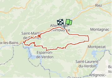

Length
34 km

Max alt
600 m

Uphill gradient
683 m
Km-Effort
43 km

Min alt
380 m

Downhill gradient
682 m
Boucle
Yes
Creation date :
2022-08-03 06:37:55.874
Updated on :
2022-08-03 09:28:09.942
2h34
Difficulty : Medium

FREE GPS app for hiking
 SityTrail
IGN / Geographical institutes
SityTrail Plus
The world is yours!
About
Trail Mountain bike of 34 km to be discovered at Provence-Alpes-Côte d'Azur, Alpes-de-Haute-Provence, Allemagne-en-Provence. This trail is proposed by bernardcornu.
Positioning
Country:
France
Region :
Provence-Alpes-Côte d'Azur
Department/Province :
Alpes-de-Haute-Provence
Municipality :
Allemagne-en-Provence
Location:
Unknown
Start:(Dec)
Start:(UTM)
260013 ; 4851719 (32T) N.
Comments