


aigoual

Bwattier
User
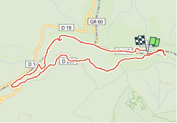

Length
5.6 km

Max alt
1562 m

Uphill gradient
155 m
Km-Effort
7.7 km

Min alt
1416 m

Downhill gradient
156 m
Boucle
Yes
Creation date :
2022-08-03 08:55:24.368
Updated on :
2022-08-03 10:49:27.955
1h53
Difficulty : Medium

FREE GPS app for hiking
 SityTrail
IGN / Geographical institutes
SityTrail Plus
The world is yours!
About
Trail Walking of 5.6 km to be discovered at Occitania, Gard, Val-d'Aigoual. This trail is proposed by Bwattier.
Positioning
Country:
France
Region :
Occitania
Department/Province :
Gard
Municipality :
Val-d'Aigoual
Location:
Valleraugue
Start:(Dec)
Start:(UTM)
546334 ; 4885517 (31T) N.
Comments