


CHA - J4 - 13/09 - La ruchère > Attignat Oncin

aeldin
User
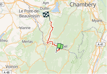

Length
23 km

Max alt
1172 m

Uphill gradient
776 m
Km-Effort
35 km

Min alt
391 m

Downhill gradient
1404 m
Boucle
No
Creation date :
2022-08-04 06:10:13.627
Updated on :
2022-09-06 18:22:06.091
4h01
Difficulty : Medium

FREE GPS app for hiking
 SityTrail
IGN / Geographical institutes
SityTrail Plus
The world is yours!
About
Trail Horseback riding of 23 km to be discovered at Auvergne-Rhône-Alpes, Isère, Saint-Christophe-sur-Guiers. This trail is proposed by aeldin.

Positioning
Country:
France
Region :
Auvergne-Rhône-Alpes
Department/Province :
Isère
Municipality :
Saint-Christophe-sur-Guiers
Location:
Unknown
Start:(Dec)
Start:(UTM)
718843 ; 5032139 (31T) N.
Comments