


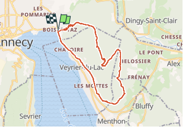
tour du Mont Veyrier

Lucquiaud
User

Length
17.7 km

Max alt
1298 m

Uphill gradient
1138 m
Km-Effort
33 km

Min alt
447 m

Downhill gradient
1138 m
Boucle
Yes
Creation date :
2022-08-04 05:02:43.079
Updated on :
2022-08-04 11:25:42.557
6h21
Difficulty : Very difficult

FREE GPS app for hiking
 SityTrail
IGN / Geographical institutes
SityTrail Plus
The world is yours!
About
Trail Walking of 17.7 km to be discovered at Auvergne-Rhône-Alpes, Upper Savoy, Annecy. This trail is proposed by Lucquiaud.
Positioning
Country:
France
Region :
Auvergne-Rhône-Alpes
Department/Province :
Upper Savoy
Municipality :
Annecy
Location:
Annecy-le-Vieux
Start:(Dec)
Start:(UTM)
279694 ; 5087341 (32T) N.
Comments