Trail Walking Laguiole - le roc des cabres - Photo

le roc des cabres

© OpenStreetMap contributors
Length
Length
13.7 km
Max alt
Max alt
1135 m
Uphill gradient
Uphill gradient
328 m
Km-Effort
Km-Effort  
18.1 km
Min alt
Min alt
940 m
Downhill gradient
Downhill gradient
331 m
Boucle
Boucle
Yes
Creation date :
2022-08-04 08:54:21.121
Updated on :
2022-08-04 13:28:55.854

(0 Reviews)

Walking
Walking
4h16
Difficulty : Easy
Mountain bike
Mountain bike
4h17
Difficulty : Easy

Scan this QR Code to open this trail in the SityTrail application

FREE GPS app for hiking

Logo SityTrail SityTrail

IGN / Geographical institutes

Download SityTrail from the App Store Download SityTrail from Google Play

Logo SityTrail SityTrail World

The world is yours!

Download SityTrail from the App Store Download SityTrail from Google Play Download SityTrail on Huawei AppGallery

About

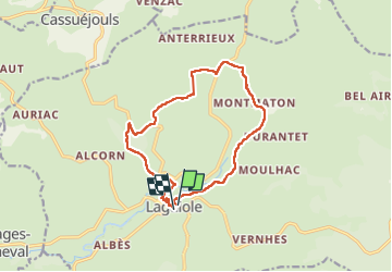
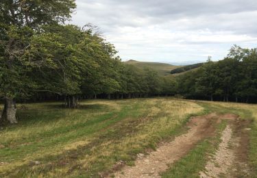
Trail Walking of 13.7 km to be discovered at Occitania, Aveyron, Laguiole. This trail is proposed by bidetarou.

Description

Randonnée sympathique au départ de laguiole environ 13km facile à travers les montagnes accessible au VTT petite variante sur cette version via le fort de Laguiole

Elevation profile

Photos

Positioning

Country:
France
Region :
Occitania
Department/Province :
Aveyron
Municipality :
Laguiole
Location:
Unknown
Start:(UTM)
487947 ; 4947878 (31T) N.

Trails nearby

Trail Cycle Laguiole - Les courbes infinies de l'Aubrac - Laguiole - Photo
Cycle
tracegps

Cycle

Difficult
(1)
Laguiole, Occitania, Aveyron, France
75 km | 90 km-effort
5h 0min
Yes
Trail Walking Laguiole - Laguiole Roc Del Cabres  - Photo
Walking
GUIDE
antignacs

Walking

Easy
Laguiole, Occitania, Aveyron, France
12.3 km | 16.3 km-effort
3h 3min
Yes
Trail Walking Cassuéjouls - Cassuejouls 24 02 06 - Photo
Walking
GUIDE
antignacs

Walking

Very easy
Cassuéjouls, Occitania, Aveyron, France
8.8 km | 12.1 km-effort
2h 17min
Yes
Trail Walking Laguiole - Laguiole Pigasse  - Photo
Walking
Galoche

Walking

Easy
Laguiole, Occitania, Aveyron, France
6.2 km | 8.4 km-effort
1h 47min
Yes
Trail Walking Curières - la croix du Pal - Photo
Walking
bidetarou

Walking

Medium
Curières, Occitania, Aveyron, France
15.2 km | 22 km-effort
4h 29min
Yes
Trail On foot Laguiole - Laguiole PR-5 - Photo
On foot
PRO

On foot

Easy
Laguiole, Occitania, Aveyron, France
6.3 km | 8.8 km-effort
1h 59min
No
Trail Walking Laguiole - Arioubadous  - Photo
Walking
GUIDE
antignacs

Walking

Easy
Laguiole, Occitania, Aveyron, France
14.1 km | 18.1 km-effort
3h 17min
Yes
Trail Walking Laguiole - Boucle Laguiole Aveyron  - Photo
Walking
tercla

Walking

Difficult
Laguiole, Occitania, Aveyron, France
23 km | 29 km-effort
6h 34min
Yes
Trail Walking Laguiole - De Laguiole à Saint-Urcize - Photo
Walking
tracegps

Walking

Difficult
Laguiole, Occitania, Aveyron, France
16.3 km | 21 km-effort
3h 52min
No


Close
My subscriptions