


coteaux de l'Aa

tenace
User
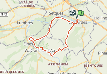

Length
15 km

Max alt
146 m

Uphill gradient
273 m
Km-Effort
18.7 km

Min alt
29 m

Downhill gradient
273 m
Boucle
Yes
Creation date :
2022-08-04 13:45:39.531
Updated on :
2022-08-04 17:35:41.192
3h47
Difficulty : Difficult

FREE GPS app for hiking
 SityTrail
IGN / Geographical institutes
SityTrail Plus
The world is yours!
About
Trail Walking of 15 km to be discovered at Hauts-de-France, Pas-de-Calais, Esquerdes. This trail is proposed by tenace.
Positioning
Country:
France
Region :
Hauts-de-France
Department/Province :
Pas-de-Calais
Municipality :
Esquerdes
Location:
Unknown
Start:(Dec)
Start:(UTM)
442235 ; 5617588 (31U) N.
Comments