


Épinal Uxegney

JeanPierreNancy
User
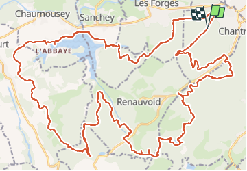

Length
43 km

Max alt
480 m

Uphill gradient
765 m
Km-Effort
53 km

Min alt
357 m

Downhill gradient
764 m
Boucle
Yes
Creation date :
2022-08-05 08:36:11.115
Updated on :
2022-08-05 15:35:37.653
3h44
Difficulty : Medium

FREE GPS app for hiking
 SityTrail
IGN / Geographical institutes
SityTrail Plus
The world is yours!
About
Trail Mountain bike of 43 km to be discovered at Grand Est, Vosges, Chantraine. This trail is proposed by JeanPierreNancy.
Positioning
Country:
France
Region :
Grand Est
Department/Province :
Vosges
Municipality :
Chantraine
Location:
Unknown
Start:(Dec)
Start:(UTM)
308117 ; 5338372 (32U) N.
Comments