


Seize- Oingt -Cogny

henristraetmans
User
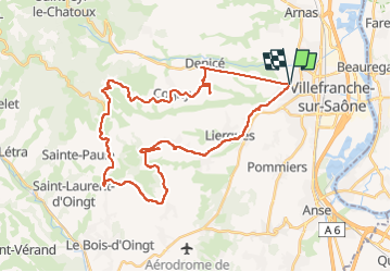

Length
40 km

Max alt
552 m

Uphill gradient
690 m
Km-Effort
50 km

Min alt
198 m

Downhill gradient
690 m
Boucle
Yes
Creation date :
2022-08-02 09:11:59.724
Updated on :
2022-08-06 08:29:14.393
2h30
Difficulty : Very difficult

FREE GPS app for hiking
 SityTrail
IGN / Geographical institutes
SityTrail Plus
The world is yours!
About
Trail Road bike of 40 km to be discovered at Auvergne-Rhône-Alpes, Rhône, Gleizé. This trail is proposed by henristraetmans.
Positioning
Country:
France
Region :
Auvergne-Rhône-Alpes
Department/Province :
Rhône
Municipality :
Gleizé
Location:
Unknown
Start:(Dec)
Start:(UTM)
631668 ; 5094502 (31T) N.
Comments