


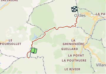
Le Taillefer via le Refuge et retour Oulles 58 +

claude nier
User

Length
8.7 km

Max alt
2851 m

Uphill gradient
58 m
Km-Effort
14.3 km

Min alt
1415 m

Downhill gradient
1485 m
Boucle
No
Creation date :
2022-08-06 11:46:15.708
Updated on :
2022-08-06 11:47:52.125
3h14
Difficulty : Easy

FREE GPS app for hiking
 SityTrail
IGN / Geographical institutes
SityTrail Plus
The world is yours!
About
Trail On foot of 8.7 km to be discovered at Auvergne-Rhône-Alpes, Isère, Lavaldens. This trail is proposed by claude nier.
Description
retour sur oulles
nuit au refuge du Taillefer
Positioning
Country:
France
Region :
Auvergne-Rhône-Alpes
Department/Province :
Isère
Municipality :
Lavaldens
Location:
Unknown
Start:(Dec)
Start:(UTM)
730302 ; 4991487 (31T) N.
Comments