Trail Walking Sainte-Ode - Magerotte - Promenade des Haies de Magery (T4) - Photo

Magerotte - Promenade des Haies de Magery (T4)

Randonnées de la Grande Forêt de Saint-Hubert GUIDE+

© OpenStreetMap contributors
Length
Length
9.3 km
Max alt
Max alt
528 m
Uphill gradient
Uphill gradient
161 m
Km-Effort
Km-Effort  
11.4 km
Min alt
Min alt
437 m
Downhill gradient
Downhill gradient
158 m
Boucle
Boucle
Yes
Creation date :
2017-09-26 00:00:00.0
Updated on :
2017-09-26 00:00:00.0

(3 Reviews)

Walking
Walking
2h29
Difficulty : Medium

Scan this QR Code to open this trail in the SityTrail application

FREE GPS app for hiking

Logo SityTrail SityTrail

IGN / Geographical institutes

Download SityTrail from the App Store Download SityTrail from Google Play

Logo SityTrail SityTrail World

The world is yours!

Download SityTrail from the App Store Download SityTrail from Google Play Download SityTrail on Huawei AppGallery

About

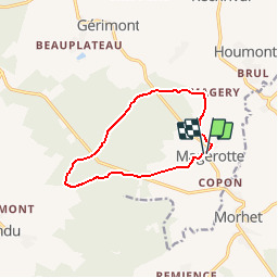
Trail Walking of 9.3 km to be discovered at Wallonia, Luxembourg, Sainte-Ode. This trail is proposed by La Grande Forêt de Saint-Hubert.

Description

Cette promenade, très agréable (particulièrement au printemps et en été) est idéale pour les familles.
L'itinéraire parcourt principalement la forêt et offre un panorama sur le village de Magerotte.

Itinéraire repris sur la carte IGN des promenades de Sainte-Ode (1:25 000) vendue à 8,00 €

Concepteur: Syndicat d'Initiative de Sainte-Ode

Elevation profile

Positioning

Country:
Belgium
Region :
Wallonia
Department/Province :
Luxembourg
Municipality :
Sainte-Ode
Location:
Tillet
Start:(UTM)
684571 ; 5539021 (31U) N.

Comments

Please log in to post a review or rate the element


Een mooie wandeling door velden en bossen, vergezeld door de plaatselijke border collie (Kenji). Een aanrader, zeker in de herfst en de winter.


Trails nearby

Trail Walking Sainte-Ode - Beauplateau - Promenade du Pleurotte (T7) - Photo
Walking
GUIDE+

Walking

Medium
(2)
Sainte-Ode, Wallonia, Luxembourg, Belgium
5.5 km | 6.9 km-effort
1h 29min
Yes
Trail Walking Sainte-Ode - Beauplateau - Le sentier du Coprin (GTA 4) - Photo
Walking
GUIDE+

Walking

Very difficult
(2)
Sainte-Ode, Wallonia, Luxembourg, Belgium
16.6 km | 20 km-effort
4h 20min
Yes
Trail Walking Sainte-Ode - Rechrival - Promenade des Haies des Valets (T3) - Photo
Walking
GUIDE+

Walking

Medium
(1)
Sainte-Ode, Wallonia, Luxembourg, Belgium
8.5 km | 10.1 km-effort
2h 12min
Yes
Trail On foot Vaux-sur-Sûre - Promenade des Vanneaux - Photo
On foot
PRO

On foot

Easy
Vaux-sur-Sûre, Wallonia, Luxembourg, Belgium
11.5 km | 14.1 km-effort
3h 12min
Yes
Trail On foot Sainte-Ode - 2. Le sentier du Cèpe de Bordeaux - Photo
On foot
PRO

On foot

Difficult
Sainte-Ode, Wallonia, Luxembourg, Belgium
26 km | 34 km-effort
7h 45min
Yes
Trail sport Sainte-Ode - SityTrail - Tillet - Promenade des Haies de Tillet (T6) - Photo
sport
AnneCecile

sport

Very easy
(1)
Sainte-Ode, Wallonia, Luxembourg, Belgium
8.6 km | 11 km-effort
Unknown
Yes
Trail Walking Sainte-Ode - Boucle - Forêts et plateaux- Tronçon 3 - Rechimont - Gives - Photo
Walking
GUIDE+

Walking

Very easy
Sainte-Ode, Wallonia, Luxembourg, Belgium
18.3 km | 22 km-effort
Unknown
No
Trail Walking Sainte-Ode - Beauplateau Ste Ode 240823 - Photo
Walking
guyernage25

Walking

Easy
Sainte-Ode, Wallonia, Luxembourg, Belgium
15.2 km | 18.2 km-effort
3h 33min
Yes
Trail On foot Vaux-sur-Sûre - Promenade de la Truite - Photo
On foot
PRO

On foot

Easy
Vaux-sur-Sûre, Wallonia, Luxembourg, Belgium
3.2 km | 4 km-effort
54min
Yes


Close
My subscriptions