


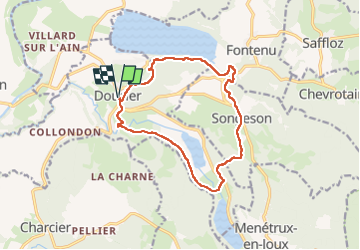
Doucier 20220804

cmike39
User

Length
13.7 km

Max alt
651 m

Uphill gradient
339 m
Km-Effort
18.2 km

Min alt
501 m

Downhill gradient
339 m
Boucle
Yes
Creation date :
2022-08-04 07:06:41.182
Updated on :
2022-08-07 09:43:00.626
6h09
Difficulty : Difficult

FREE GPS app for hiking
 SityTrail
IGN / Geographical institutes
SityTrail Plus
The world is yours!
About
Trail Walking of 13.7 km to be discovered at Bourgogne-Franche-Comté, Jura, Doucier. This trail is proposed by cmike39.
Photos


Positioning
Country:
France
Region :
Bourgogne-Franche-Comté
Department/Province :
Jura
Municipality :
Doucier
Location:
Unknown
Start:(Dec)
Start:(UTM)
712568 ; 5170679 (31T) N.
Comments