


BACH BIARGUES

PascalBanide
User
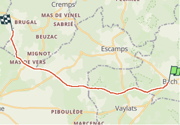

Length
11.1 km

Max alt
320 m

Uphill gradient
92 m
Km-Effort
12.5 km

Min alt
251 m

Downhill gradient
135 m
Boucle
No
Creation date :
2022-08-08 05:13:16.0
Updated on :
2022-08-08 08:04:05.666
2h49
Difficulty : Easy

FREE GPS app for hiking
 SityTrail
IGN / Geographical institutes
SityTrail Plus
The world is yours!
About
Trail Walking of 11.1 km to be discovered at Occitania, Lot, Bach. This trail is proposed by PascalBanide.
Description
Bach Biargues
Positioning
Country:
France
Region :
Occitania
Department/Province :
Lot
Municipality :
Bach
Location:
Unknown
Start:(Dec)
Start:(UTM)
394075 ; 4911615 (31T) N.
Comments