


combe de sixt

les randos d'Olivier
partout a pied et en moto
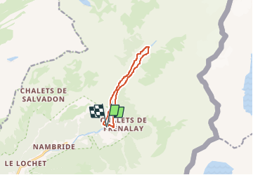

Length
8.1 km

Max alt
1072 m

Uphill gradient
193 m
Km-Effort
10.6 km

Min alt
943 m

Downhill gradient
192 m
Boucle
Yes
Creation date :
2022-08-09 07:42:17.206
Updated on :
2022-08-09 07:42:34.423
2h24
Difficulty : Medium

FREE GPS app for hiking
 SityTrail
IGN / Geographical institutes
SityTrail Plus
The world is yours!
About
Trail Walking of 8.1 km to be discovered at Auvergne-Rhône-Alpes, Upper Savoy, Sixt-Fer-à-Cheval. This trail is proposed by les randos d'Olivier.
Positioning
Country:
France
Region :
Auvergne-Rhône-Alpes
Department/Province :
Upper Savoy
Municipality :
Sixt-Fer-à-Cheval
Location:
Unknown
Start:(Dec)
Start:(UTM)
332757 ; 5104963 (32T) N.
Comments