


T1

pidjam
User

Length
6.8 km

Max alt
173 m

Uphill gradient
112 m
Km-Effort
8.3 km

Min alt
106 m

Downhill gradient
113 m
Boucle
Yes
Creation date :
2022-08-09 08:29:05.414
Updated on :
2022-08-09 08:30:22.066
1h53
Difficulty : Medium

FREE GPS app for hiking
 SityTrail
IGN / Geographical institutes
SityTrail Plus
The world is yours!
About
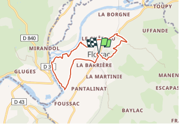
Trail Walking of 6.8 km to be discovered at Occitania, Lot, Floirac. This trail is proposed by pidjam.
Description
petite rando proposée par les offices du tourisme
Positioning
Country:
France
Region :
Occitania
Department/Province :
Lot
Municipality :
Floirac
Location:
Unknown
Start:(Dec)
Start:(UTM)
393820 ; 4974420 (31T) N.
Comments