


rando vtt ocgif 10 08 22

marcagif
User
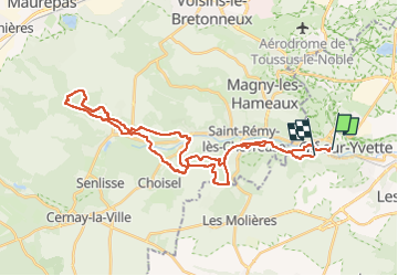

Length
36 km

Max alt
177 m

Uphill gradient
651 m
Km-Effort
45 km

Min alt
62 m

Downhill gradient
622 m
Boucle
No
Creation date :
2022-08-10 07:05:14.318
Updated on :
2022-08-10 10:36:57.786
3h00
Difficulty : Medium

FREE GPS app for hiking
 SityTrail
IGN / Geographical institutes
SityTrail Plus
The world is yours!
About
Trail Mountain bike of 36 km to be discovered at Ile-de-France, Essonne, Gif-sur-Yvette. This trail is proposed by marcagif.
Positioning
Country:
France
Region :
Ile-de-France
Department/Province :
Essonne
Municipality :
Gif-sur-Yvette
Location:
Unknown
Start:(Dec)
Start:(UTM)
435672 ; 5394593 (31U) N.
Comments