


SityTrail - Angleur_sart-tilman 2

Jeanedouard
User
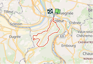

Length
10 km

Max alt
241 m

Uphill gradient
223 m
Km-Effort
13 km

Min alt
64 m

Downhill gradient
223 m
Boucle
Yes
Creation date :
2022-08-10 16:21:21.273
Updated on :
2024-06-08 07:31:12.149
2h56
Difficulty : Difficult

FREE GPS app for hiking
 SityTrail
IGN / Geographical institutes
SityTrail Plus
The world is yours!
About
Trail Walking of 10 km to be discovered at Wallonia, Liège, Liège. This trail is proposed by Jeanedouard.
Description
Boucle bois route
Positioning
Country:
Belgium
Region :
Wallonia
Department/Province :
Liège
Municipality :
Liège
Location:
Angleur
Start:(Dec)
Start:(UTM)
683320 ; 5610320 (31U) N.
Comments