


20140913 Rando CVA Vercors Theorique

holtzv
User GUIDE
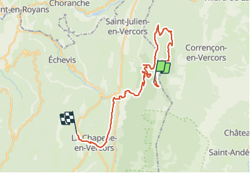

Length
29 km

Max alt
1531 m

Uphill gradient
727 m
Km-Effort
41 km

Min alt
696 m

Downhill gradient
1206 m
Boucle
No
Creation date :
2014-12-10 00:00:00.0
Updated on :
2014-12-10 00:00:00.0
4h56
Difficulty : Unknown

FREE GPS app for hiking
 SityTrail
IGN / Geographical institutes
SityTrail Plus
The world is yours!
About
Trail Equestrian of 29 km to be discovered at Auvergne-Rhône-Alpes, Drôme, Saint-Martin-en-Vercors. This trail is proposed by holtzv.


Positioning
Country:
France
Region :
Auvergne-Rhône-Alpes
Department/Province :
Drôme
Municipality :
Saint-Martin-en-Vercors
Location:
Unknown
Start:(Dec)
Start:(UTM)
695061 ; 4987106 (31T) N.
Comments