Trail Walking Tongeren - L'ancien acqueduc romain Beukenberg à Tongres - Photo

L'ancien acqueduc romain Beukenberg à Tongres

 Benjamin27
Benjamin27

User GUIDE

© OpenStreetMap contributors
Length
Length
6.9 km
Max alt
Max alt
112 m
Uphill gradient
Uphill gradient
65 m
Km-Effort
Km-Effort  
7.8 km
Min alt
Min alt
71 m
Downhill gradient
Downhill gradient
65 m
Boucle
Boucle
Yes
Creation date :
2022-08-11 00:14:50.667
Updated on :
2024-07-07 15:47:28.398

(2 Reviews)

Walking
Walking
1h46
Difficulty : Medium

Scan this QR Code to open this trail in the SityTrail application

FREE GPS app for hiking

Logo SityTrail SityTrail

IGN / Geographical institutes

Download SityTrail from the App Store Download SityTrail from Google Play

Logo SityTrail SityTrail Plus

The world is yours!

Download SityTrail from the App Store Download SityTrail from Google Play Download SityTrail on Huawei AppGallery

About

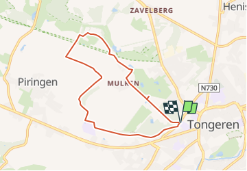
Trail Walking of 6.9 km to be discovered at Flanders, Limburg, Tongeren. This trail is proposed by Benjamin27.

Description

Promenade près d’un ancien aqueduc romain à côté de Tongres. Entre champs, vergers et bois, la balade vous mènera sur une colline assez étroite qui servait à acheminer l’eau vers la ville de Tongres.

👣 Distance : 7km - balisage flèche rouge.

📍Départ : allée du château de Betho, Mulkerweg 4 - 3700 Tongeren.

🚂🚍 Aller à la gare de Hasselt et prendre le bus DE LIJN 4 jusqu’à l’arrêt « Tongeren - Mulkerweg ».

Elevation profile

Photos

Positioning

Country:
Belgium
Region :
Flanders
Department/Province :
Limburg
Municipality :
Tongeren
Location:
Tongeren
Start:(UTM)
673112 ; 5628335 (31U) N.

Comments

Please log in to post a review or rate the element


Close
My subscriptions