


Evelle melin st Romain bas et haut haut de Orches

iznogud
User
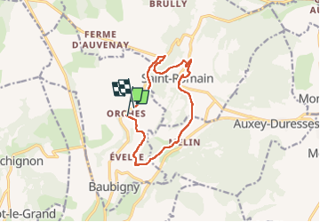

Length
10.8 km

Max alt
536 m

Uphill gradient
359 m
Km-Effort
15.5 km

Min alt
301 m

Downhill gradient
311 m
Boucle
No
Creation date :
2022-08-11 07:40:03.0
Updated on :
2022-08-11 09:50:10.929
2h09
Difficulty : Unknown

FREE GPS app for hiking
 SityTrail
IGN / Geographical institutes
SityTrail Plus
The world is yours!
About
Trail Trail of 10.8 km to be discovered at Bourgogne-Franche-Comté, Côte-d'Or, Baubigny. This trail is proposed by iznogud.
Positioning
Country:
France
Region :
Bourgogne-Franche-Comté
Department/Province :
Côte-d'Or
Municipality :
Baubigny
Location:
Unknown
Start:(Dec)
Start:(UTM)
628438 ; 5205231 (31T) N.
Comments