


forêt 🐿 Guînes 11 08 2022

tenace
User
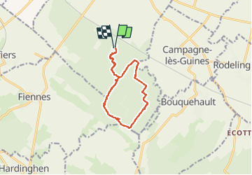

Length
12 km

Max alt
174 m

Uphill gradient
172 m
Km-Effort
14.3 km

Min alt
65 m

Downhill gradient
175 m
Boucle
Yes
Creation date :
2022-08-11 13:30:42.891
Updated on :
2022-08-11 17:34:01.26
2h42
Difficulty : Difficult

FREE GPS app for hiking
 SityTrail
IGN / Geographical institutes
SityTrail Plus
The world is yours!
About
Trail Walking of 12 km to be discovered at Hauts-de-France, Pas-de-Calais, Guînes. This trail is proposed by tenace.
Photos

Positioning
Country:
France
Region :
Hauts-de-France
Department/Province :
Pas-de-Calais
Municipality :
Guînes
Location:
Unknown
Start:(Dec)
Start:(UTM)
420193 ; 5633031 (31U) N.
Comments