


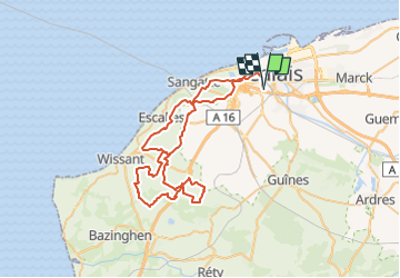
59-km-roc-opale-2017

topolino
User

Length
60 km

Max alt
163 m

Uphill gradient
957 m
Km-Effort
73 km

Min alt
-4 m

Downhill gradient
957 m
Boucle
Yes
Creation date :
2022-08-12 16:06:18.057
Updated on :
2022-08-12 16:06:18.057
5h01
Difficulty : Very difficult

FREE GPS app for hiking
 SityTrail
IGN / Geographical institutes
SityTrail Plus
The world is yours!
About
Trail Mountain bike of 60 km to be discovered at Hauts-de-France, Pas-de-Calais, Calais. This trail is proposed by topolino.
Description
vttttttttttttttttttttttttttttttttttttttttttttttttttt
Positioning
Country:
France
Region :
Hauts-de-France
Department/Province :
Pas-de-Calais
Municipality :
Calais
Location:
Unknown
Start:(Dec)
Start:(UTM)
418510 ; 5643761 (31U) N.
Comments