


n34 Lac de Barbeyroux

jeanguil
User
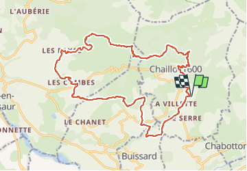

Length
23 km

Max alt
1774 m

Uphill gradient
805 m
Km-Effort
34 km

Min alt
1253 m

Downhill gradient
804 m
Boucle
Yes
Creation date :
2022-08-13 07:38:08.341
Updated on :
2023-04-01 08:27:06.408
3h00
Difficulty : Medium

FREE GPS app for hiking
 SityTrail
IGN / Geographical institutes
SityTrail Plus
The world is yours!
About
Trail Mountain bike of 23 km to be discovered at Provence-Alpes-Côte d'Azur, Hautes-Alpes, Saint-Michel-de-Chaillol. This trail is proposed by jeanguil.
Description
Parcours 34 Lac de Barbeyroux
Positioning
Country:
France
Region :
Provence-Alpes-Côte d'Azur
Department/Province :
Hautes-Alpes
Municipality :
Saint-Michel-de-Chaillol
Location:
Unknown
Start:(Dec)
Start:(UTM)
275789 ; 4951140 (32T) N.
Comments