


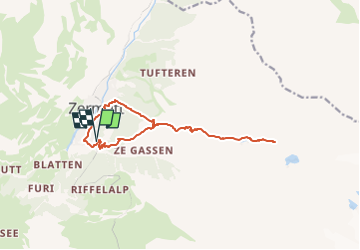
Test Cervin - Sunega - Flue Alp

marinec1964
User

Length
13.7 km

Max alt
2612 m

Uphill gradient
1049 m
Km-Effort
28 km

Min alt
1616 m

Downhill gradient
1043 m
Boucle
Yes
Creation date :
2022-08-13 14:51:56.0
Updated on :
2022-08-13 14:51:57.479
6h17
Difficulty : Very difficult

FREE GPS app for hiking
 SityTrail
IGN / Geographical institutes
SityTrail Plus
The world is yours!
About
Trail Walking of 13.7 km to be discovered at Valais/Wallis, Visp, Zermatt. This trail is proposed by marinec1964.
Description
Lac - baignade
Positioning
Country:
Switzerland
Region :
Valais/Wallis
Department/Province :
Visp
Municipality :
Zermatt
Location:
Unknown
Start:(Dec)
Start:(UTM)
403199 ; 5096248 (32T) N.
Comments