


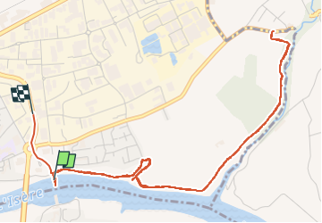
Les Anes voie verte

meillon
User

Length
7 km

Max alt
174 m

Uphill gradient
92 m
Km-Effort
8.2 km

Min alt
145 m

Downhill gradient
67 m
Boucle
No
Creation date :
2022-08-14 18:03:48.362
Updated on :
2022-08-14 20:12:59.206
2h08
Difficulty : Easy

FREE GPS app for hiking
 SityTrail
IGN / Geographical institutes
SityTrail Plus
The world is yours!
About
Trail Walking of 7 km to be discovered at Auvergne-Rhône-Alpes, Drôme, Romans-sur-Isère. This trail is proposed by meillon.
Positioning
Country:
France
Region :
Auvergne-Rhône-Alpes
Department/Province :
Drôme
Municipality :
Romans-sur-Isère
Location:
Unknown
Start:(Dec)
Start:(UTM)
664323 ; 4989652 (31T) N.
Comments