


vieux Rhin

apa
User
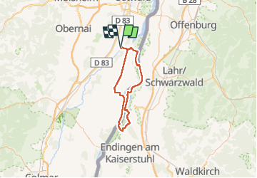

Length
67 km

Max alt
181 m

Uphill gradient
518 m
Km-Effort
74 km

Min alt
144 m

Downhill gradient
519 m
Boucle
Yes
Creation date :
2022-08-14 07:47:10.03
Updated on :
2022-08-15 14:52:22.001
3h37
Difficulty : Medium

FREE GPS app for hiking
 SityTrail
IGN / Geographical institutes
SityTrail Plus
The world is yours!
About
Trail Electric bike of 67 km to be discovered at Grand Est, Bas-Rhin, Erstein. This trail is proposed by apa.
Description
autour du Rhin France Allemagne
Rhin bucolique
Photos


Positioning
Country:
France
Region :
Grand Est
Department/Province :
Bas-Rhin
Municipality :
Erstein
Location:
Unknown
Start:(Dec)
Start:(UTM)
401164 ; 5363151 (32U) N.
Comments