


Aout182022

FPortier
User
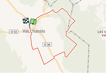

Length
8.3 km

Max alt
271 m

Uphill gradient
166 m
Km-Effort
10.5 km

Min alt
182 m

Downhill gradient
167 m
Boucle
Yes
Creation date :
2022-08-15 15:42:53.053
Updated on :
2022-08-18 05:39:53.124
2h23
Difficulty : Medium

FREE GPS app for hiking
 SityTrail
IGN / Geographical institutes
SityTrail Plus
The world is yours!
About
Trail Walking of 8.3 km to be discovered at Grand Est, Aube, Vauchassis. This trail is proposed by FPortier.
Positioning
Country:
France
Region :
Grand Est
Department/Province :
Aube
Municipality :
Vauchassis
Location:
Unknown
Start:(Dec)
Start:(UTM)
568453 ; 5341407 (31U) N.
Comments