


Raucoules Riotord

HAL26
User
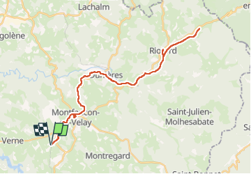

Length
41 km

Max alt
924 m

Uphill gradient
606 m
Km-Effort
49 km

Min alt
781 m

Downhill gradient
607 m
Boucle
Yes
Creation date :
2022-08-16 08:27:30.117
Updated on :
2022-08-16 13:15:55.006
4h02
Difficulty : Very difficult

FREE GPS app for hiking
 SityTrail
IGN / Geographical institutes
SityTrail Plus
The world is yours!
About
Trail Mountain bike of 41 km to be discovered at Auvergne-Rhône-Alpes, Haute-Loire, Raucoules. This trail is proposed by HAL26.
Positioning
Country:
France
Region :
Auvergne-Rhône-Alpes
Department/Province :
Haute-Loire
Municipality :
Raucoules
Location:
Unknown
Start:(Dec)
Start:(UTM)
601424 ; 5002225 (31T) N.
Comments