


Part of Hardergrat (augstmatthorn, suggiturre, Wytlouwihoren ...)

Bruno566
User
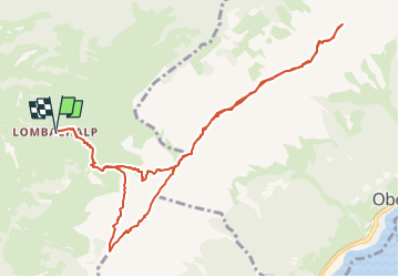

Length
11.9 km

Max alt
2122 m

Uphill gradient
1049 m
Km-Effort
26 km

Min alt
1559 m

Downhill gradient
1049 m
Boucle
Yes
Creation date :
2022-08-16 20:14:36.101
Updated on :
2022-08-16 20:35:40.629
4h00
Difficulty : Medium

FREE GPS app for hiking
 SityTrail
IGN / Geographical institutes
SityTrail Plus
The world is yours!
About
Trail Walking of 11.9 km to be discovered at Bern, Interlaken-Oberhasli administrative district, Habkern. This trail is proposed by Bruno566.
Positioning
Country:
Switzerland
Region :
Bern
Department/Province :
Interlaken-Oberhasli administrative district
Municipality :
Habkern
Location:
Unknown
Start:(Dec)
Start:(UTM)
416552 ; 5177352 (32T) N.
Comments