


20140911 Rando CVA Vercors Theorique Opt01

holtzv
User GUIDE
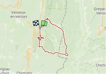

Length
28 km

Max alt
1669 m

Uphill gradient
885 m
Km-Effort
40 km

Min alt
976 m

Downhill gradient
887 m
Boucle
Yes
Creation date :
2014-12-10 00:00:00.0
Updated on :
2014-12-10 00:00:00.0
4h48
Difficulty : Unknown

FREE GPS app for hiking
 SityTrail
IGN / Geographical institutes
SityTrail Plus
The world is yours!
About
Trail Equestrian of 28 km to be discovered at Auvergne-Rhône-Alpes, Drôme, Saint-Agnan-en-Vercors. This trail is proposed by holtzv.


Positioning
Country:
France
Region :
Auvergne-Rhône-Alpes
Department/Province :
Drôme
Municipality :
Saint-Agnan-en-Vercors
Location:
Unknown
Start:(Dec)
Start:(UTM)
691276 ; 4971341 (31T) N.
Comments