


La Chapelle de Servières

jpb83
User
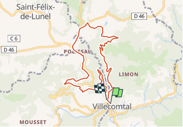

Length
9.5 km

Max alt
540 m

Uphill gradient
316 m
Km-Effort
13.7 km

Min alt
304 m

Downhill gradient
307 m
Boucle
Yes
Creation date :
2022-08-17 07:14:51.399
Updated on :
2022-08-17 07:16:30.723
3h06
Difficulty : Easy

FREE GPS app for hiking
 SityTrail
IGN / Geographical institutes
SityTrail Plus
The world is yours!
About
Trail Walking of 9.5 km to be discovered at Occitania, Aveyron, Villecomtal. This trail is proposed by jpb83.


Positioning
Country:
France
Region :
Occitania
Department/Province :
Aveyron
Municipality :
Villecomtal
Location:
Unknown
Start:(Dec)
Start:(UTM)
465340 ; 4931894 (31T) N.
Comments