


vtt au tour de malaucene

melsacri
User
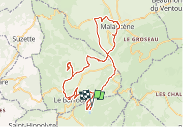

Length
24 km

Max alt
407 m

Uphill gradient
475 m
Km-Effort
30 km

Min alt
276 m

Downhill gradient
480 m
Boucle
Yes
Creation date :
2022-08-17 07:31:17.255
Updated on :
2022-08-17 11:09:48.585
3h37
Difficulty : Medium

FREE GPS app for hiking
 SityTrail
IGN / Geographical institutes
SityTrail Plus
The world is yours!
About
Trail Mountain bike of 24 km to be discovered at Provence-Alpes-Côte d'Azur, Vaucluse, Caromb. This trail is proposed by melsacri.
Positioning
Country:
France
Region :
Provence-Alpes-Côte d'Azur
Department/Province :
Vaucluse
Municipality :
Caromb
Location:
Unknown
Start:(Dec)
Start:(UTM)
669202 ; 4888988 (31T) N.
Comments