


Oeschinensee sans les télécabines

Bruno566
User
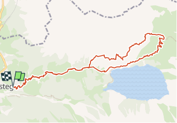

Length
12.6 km

Max alt
2027 m

Uphill gradient
976 m
Km-Effort
26 km

Min alt
1202 m

Downhill gradient
976 m
Boucle
Yes
Creation date :
2022-08-17 11:37:28.389
Updated on :
2022-08-17 12:13:47.758
3h00
Difficulty : Medium

FREE GPS app for hiking
 SityTrail
IGN / Geographical institutes
SityTrail Plus
The world is yours!
About
Trail Walking of 12.6 km to be discovered at Bern, Frutigen-Niedersimmental administrative district, Kandersteg. This trail is proposed by Bruno566.
Positioning
Country:
Switzerland
Region :
Bern
Department/Province :
Frutigen-Niedersimmental administrative district
Municipality :
Kandersteg
Location:
Unknown
Start:(Dec)
Start:(UTM)
398877 ; 5150142 (32T) N.
Comments