


Jura 9

Pascal Bernaud
User

Length
19.1 km

Max alt
1202 m

Uphill gradient
647 m
Km-Effort
27 km

Min alt
860 m

Downhill gradient
472 m
Boucle
No
Creation date :
2022-08-17 06:27:38.0
Updated on :
2022-08-17 12:46:39.98
6h18
Difficulty : Very difficult

FREE GPS app for hiking
 SityTrail
IGN / Geographical institutes
SityTrail Plus
The world is yours!
About
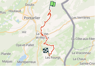
Trail Walking of 19.1 km to be discovered at Bourgogne-Franche-Comté, Doubs, Pontarlier. This trail is proposed by Pascal Bernaud.
Positioning
Country:
France
Region :
Bourgogne-Franche-Comté
Department/Province :
Doubs
Municipality :
Pontarlier
Location:
Unknown
Start:(Dec)
Start:(UTM)
301981 ; 5199371 (32T) N.
Comments