


Orches melin montagne de savoie la rochepot table d orientation

iznogud
User
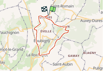

Length
12.7 km

Max alt
564 m

Uphill gradient
413 m
Km-Effort
18.2 km

Min alt
295 m

Downhill gradient
413 m
Boucle
Yes
Creation date :
2022-08-17 10:41:25.0
Updated on :
2022-08-17 12:56:54.48
2h14
Difficulty : Very difficult

FREE GPS app for hiking
 SityTrail
IGN / Geographical institutes
SityTrail Plus
The world is yours!
About
Trail Trail of 12.7 km to be discovered at Bourgogne-Franche-Comté, Côte-d'Or, Baubigny. This trail is proposed by iznogud.
Positioning
Country:
France
Region :
Bourgogne-Franche-Comté
Department/Province :
Côte-d'Or
Municipality :
Baubigny
Location:
Unknown
Start:(Dec)
Start:(UTM)
628657 ; 5205484 (31T) N.
Comments