


SityTrail - lac d airon

les randos d'Olivier
partout a pied et en moto
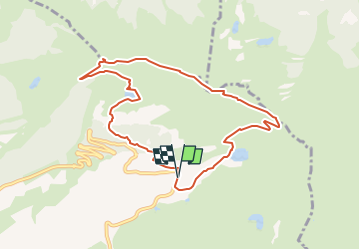

Length
8.9 km

Max alt
2109 m

Uphill gradient
433 m
Km-Effort
14.6 km

Min alt
1699 m

Downhill gradient
433 m
Boucle
Yes
Creation date :
2022-08-18 07:07:13.278
Updated on :
2022-08-18 07:10:40.677
3h19
Difficulty : Difficult

FREE GPS app for hiking
 SityTrail
IGN / Geographical institutes
SityTrail Plus
The world is yours!
About
Trail Walking of 8.9 km to be discovered at Auvergne-Rhône-Alpes, Upper Savoy, Arâches-la-Frasse. This trail is proposed by les randos d'Olivier.
Positioning
Country:
France
Region :
Auvergne-Rhône-Alpes
Department/Province :
Upper Savoy
Municipality :
Arâches-la-Frasse
Location:
Unknown
Start:(Dec)
Start:(UTM)
321188 ; 5098924 (32T) N.
Comments