


Rumba à limour

philou91
User

Length
11.9 km

Max alt
177 m

Uphill gradient
143 m
Km-Effort
13.8 km

Min alt
129 m

Downhill gradient
144 m
Boucle
Yes
Creation date :
2022-08-18 08:36:27.266
Updated on :
2022-08-18 12:31:09.863
3h28
Difficulty : Medium

FREE GPS app for hiking
 SityTrail
IGN / Geographical institutes
SityTrail Plus
The world is yours!
About
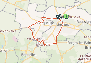
Trail Walking of 11.9 km to be discovered at Ile-de-France, Essonne, Limours. This trail is proposed by philou91.
Description
balade à faire un jour sans soleil
Photos


Positioning
Country:
France
Region :
Ile-de-France
Department/Province :
Essonne
Municipality :
Limours
Location:
Unknown
Start:(Dec)
Start:(UTM)
431910 ; 5388689 (31U) N.
Comments