


Tour de Miserey

dcharbonnier
User
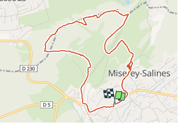

Length
5.7 km

Max alt
331 m

Uphill gradient
126 m
Km-Effort
7.4 km

Min alt
268 m

Downhill gradient
125 m
Boucle
Yes
Creation date :
2022-08-18 12:13:31.233
Updated on :
2022-08-18 13:56:53.303
1h42
Difficulty : Easy

FREE GPS app for hiking
 SityTrail
IGN / Geographical institutes
SityTrail Plus
The world is yours!
About
Trail Walking of 5.7 km to be discovered at Bourgogne-Franche-Comté, Doubs, Miserey-Salines. This trail is proposed by dcharbonnier.
Description
par la tranchée du Tacot
Positioning
Country:
France
Region :
Bourgogne-Franche-Comté
Department/Province :
Doubs
Municipality :
Miserey-Salines
Location:
Unknown
Start:(Dec)
Start:(UTM)
724493 ; 5241066 (31T) N.
Comments